Contango Intersects 506 g/t AgEq over 13.90 Meters at Torbrit and 807 g/t AgEq over 4.96 Meters at North Star Infill and Expansion Drilling
Fairbanks, Alaska--(Newsfile Corp. - September 15, 2026) - Contango Silver and Gold Inc. (NYSE American: CTGO) (TSX: CTGO) ("Contango" or the "Company") is pleased to announce initial assay results from the Torbrit and North Star silver deposits as part of the ongoing 2026 infill and expansion diamond drilling program at the Kitsault Valley Project, located in Northwest British Columbia's Golden Triangle. Highlighting these results, systematic step-out drilling has confirmed a mineralized zone connecting the Torbrit and North Star silver deposits. Notable high-grade, primary silver intercepts include 506 g/t AgEq over 13.90 meters in drill hole DV26-480 at Torbrit, and 807 g/t AgEq over 4.96 meters in drill hole DV26-494, located over 300 meters to the southwest at North Star.
Highlights
- DV26-480 (Torbrit): 506 g/t AgEq over 13.90 meters, including 881 g/t AgEq over 2.30 meters within a broader mineralized zone of 25.00 meters grading 304 g/t AgEq;
- DV26-488 (Torbrit): 272 g/t AgEq over 5.54 meters, and 0.98m of 2,878 g/t AgEq within 2.00 meters of 1,576 g/t AgEq;
- DV26-494 (North Star): 807 g/t AgEq over 4.96 meters, including 2,254 g/t AgEq over 1.00 meter; and
- DV26-515 (Torbrit): Several zones include an Upper zone (with lens A and B); and a Lower zone: Upper zone grading 33.50 meters of 262 g/t AgEq with lens A grading 436 g/t AgEq over 6.70 meters, and lens B grading 294 g/t AgEq over 17.00 meters including 1,071 g/t AgEq over 1.00 meter; and the Lower zone grading 66.35 meters of 165 g/t AgEq.
Rick Van Nieuwenhuyse, the Company's Chief Executive Officer said, "Infill drilling continues to demonstrate exceptional grade and continuity at Kitsault Valley-delivering 500 to 2,800+ g/t silver values over thick intervals that routinely match or beat our resource estimates. Keep in mind that over 90% of silver equivalent grades are due to the silver content and not base metals which is why Kitsault hosts such exceptional primary silver deposits.
Thanks to exceptional drilling efficiencies on site this season, we've been able to expand our campaign to over 50,000 meters. Crucially, systematic step-out drilling between Torbrit and North Star has now defined a clear structural link, proving these deposits are part of one unified, interconnected silver system. It's important to note that none of this 2026 drilling is incorporated into our Mineral Resource Estimate update due later this month, meaning these initial results-and those still to come-represent brand-new growth upside that will feed directly into future resource expansion and mine planning. Confirming this mineralized corridor marks a major milestone for the project, laying the foundation to potentially merge two separate deposits into a single, integrated mine plan with shared development infrastructure. We have plenty more assays coming from the 2026 program and I eagerly anticipate the next batch of results."
2026 Kitsault Valley Drill Program
Mobilized in late May 2026 with five diamond drill rigs, the Kitsault Valley program was initially scoped at 40,000 meters but has expanded toward +50,000 meters thanks to exceptional operational efficiencies on site. Drilling has focused on infill and step-out expansion around established mineral resources, as well as testing multiple high-priority regional targets. The campaign covers the entire project footprint, spanning the silver-dominant Dolly Varden Target Area in the south, which includes Torbrit, North Star, Wolf, and the recently defined 470 target, as well as the gold-dominant Homestake Target Area in the north (Figure 1). Assays for the majority of the ongoing 2026 program remain pending and will be reported in batches as results are finalized.
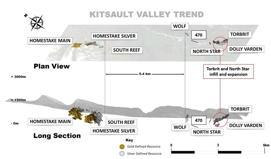
Figure 1. Plan and long sectional view of the Kitsault Valley Project highlighting 2026 Torbrit and North Star drilling area from this release.
To view an enhanced version of this graphic, please visit:
https://images.newsfilecorp.com/files/12610/314349_1c533b84849d291c_002full.jpg
The start of this season's drill program focused on the Torbrit and North Star deposits, where drilling has now successfully confirmed these two deposits form a connected mineralized system. Step-out drilling into the gap between the two deposits successfully intersected mineralization, demonstrating the continuity of mineralization below the valley bottom (Figures 2&3). These new step-out intercepts will be integrated into our evolving geological model and will drive a subsequent Mineral Resource Estimate (MRE) planned for 2027, providing immediate upside on top of our imminent 2026 MRE update.
Exploration Drill Results: Torbrit and North Star
The Torbrit and North Star silver deposits are characterized by barite rich stratiform mineralization overprinted by epithermal veining and brecciation, delivering high-grade silver and localized base metal values. Mineralization across both deposits consists of native silver, pyrargyrite, argentite, silver sulphosalts, argentiferous galena, and sphalerite.
Infill drilling at Torbrit and North Star delivered robust silver and base metal grades while upgrading confidence across wider-spaced areas that were previously modelled based on historic underground drilling from the 1960s. This year to date, 32 drill holes have been completed at Torbrit, with an additional 21 drill holes targeting North Star and the connection zone between the two deposits (Figures 2&3). Drilling remains active with one drill continuing expansion work along the North Star-Torbrit linkage, with 3 additional drills currently turning across the Homestake Target area, newly defined 470 target and Wolf deposit areas. The fifth rig has been demobilized.
This release includes initial assays from 34 holes across the Torbrit and North Star silver deposits, as detailed in Table 1 below. All reported downhole core lengths approximate 80% to 95% of true width, as drilling was oriented as close to perpendicular to the mineralized zones as possible. Assays for the balance of the 2026 program remain pending and will be released in batches as results are validated.
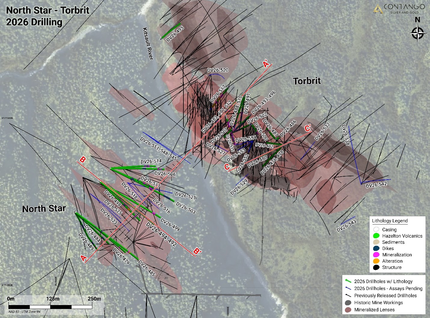
Figure 2. Plan view of the 2026 Torbrit and North Star drilling, including drill holes from this release and pending results shown with lithology. Historic drilling is shown with black drill hole traces.
To view an enhanced version of this graphic, please visit:
https://images.newsfilecorp.com/files/12610/314349_1c533b84849d291c_004full.jpg
Rob van Egmond, P.Geo, and the Company's Vice President Exploration - Canada stated, "The initial Torbrit and North Star results improve confidence in the geological model and confirm the interconnectivity of the silver system in the southern portion of the property. Highlighted intercepts demonstrate strong silver dominance, with elemental silver accounting for approximately 90% to 94% of the calculated silver-equivalent grade across both infill and expansion drilling. Standout hits like 881 g/t silver-equivalent over 2.30 meters in DV26-480 and 262 g/t silver-equivalent over 33.50 meters in DV26-515 showcase the exceptional grade and scale of these deposits-frequently featuring exciting mineralogy with visible native silver, pyrargyrite, and coarse argentite overprinted on barite-rich stratiform zones. Crucially, step-out drilling has proven physical continuity across the valley floor between Torbrit and North Star, while infill drilling has successfully validated historic 1960s underground data to solidify structural continuity in our 3D model."
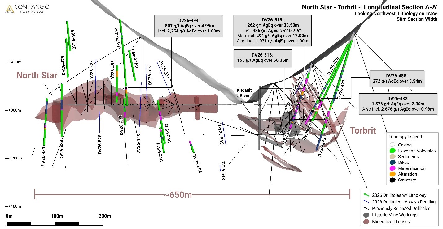
Figure 3. Long-section type Cross-sectional view A-A' of Torbrit with North Star to the west with the mineralized horizon dipping away. Historic underground levels and stopes are shown in grey.
To view an enhanced version of this graphic, please visit:
https://images.newsfilecorp.com/files/12610/314349_1c533b84849d291c_005full.jpg
Table 1. Drill hole results from Torbrit and North Star deposit areas
| Target | Hole ID | From | To | Total (m) | Ag (g/t) | Pb (%) | Zn (%) | Au (g/t) | AgEQ (g/t) | ||
| Torbrit | DV26-476 | 169.22 | 193.77 | 24.55 | 142 | 0.28 | 0.19 | 0.01 | 148 | ||
| including | 192.43 | 193.77 | 1.34 | 600 | 0.75 | 0.47 | 0.01 | 616 | |||
| DV26-477 | 165.95 | 176.02 | 10.07 | 197 | 1.27 | 0.49 | 0.01 | 220 | |||
| including | 175.22 | 176.02 | 0.8 | 344 | 8.4 | 0.29 | 0.01 | 447 | |||
| DV26-478 | 114 | 126 | 12 | 77 | 0.02 | 0.05 | 0.01 | 78 | |||
| including | 114 | 116.47 | 2.47 | 246 | 0.04 | 0.03 | 0.01 | 247 | |||
| 135.67 | 153.88 | 18.21 | 30 | 0.46 | 0.45 | 0.01 | 42 | ||||
| DV26-480 | 146 | 171 | 25 | 300 | 0.15 | 0.18 | 0.01 | 304 | |||
| including | 157.1 | 171 | 13.9 | 499 | 0.24 | 0.25 | 0.01 | 506 | |||
| including | 161.65 | 163.95 | 2.3 | 872 | 0.31 | 0.37 | 0.01 | 881 | |||
| DV26-482 | N/S | ||||||||||
| DV26-483 | 172 | 184.53 | 12.53 | 77 | 0.16 | 0.23 | 0.01 | 83 | |||
| including | 172 | 177.8 | 5.8 | 149 | 0.33 | 0.35 | 0.01 | 159 | |||
| DV26-486 | 158.18 | 195.2 | 37.02 | 20 | 0.26 | 0.24 | 0.01 | 27 | |||
| including | 159.18 | 160.53 | 1.35 | 117 | 2.66 | 3.62 | 0.03 | 205 | |||
| DV26-487 | 202.28 | 205.43 | 3.15 | 120 | 1.43 | 4.86 | 0.01 | 211 | |||
| DV26-488 | 156.47 | 162.01 | 5.54 | 232 | 1.26 | 1.62 | 0.02 | 272 | |||
| 188.75 | 190.75 | 2 | 1566 | 0.17 | 0.49 | 0.01 | 1576 | ||||
| including | 189.77 | 190.75 | 0.98 | 2860 | 0.28 | 0.9 | 0.01 | 2878 | |||
| 199.5 | 217.01 | 17.51 | 112 | 0.46 | 0.31 | 0.01 | 123 | ||||
| including | 199.5 | 208.62 | 9.12 | 169 | 0.32 | 0.2 | 0.01 | 176 | |||
| DV26-491 | 167.9 | 174 | 6.1 | 87 | 0.41 | 0.18 | 0.01 | 95 | |||
| DV26-493 | 186.7 | 223.1 | 36.4 | 121 | 0.57 | 0.29 | 0.01 | 133 | |||
| including | 196.3 | 200.33 | 4.03 | 179 | 3.54 | 0.09 | 0.01 | 222 | |||
| 217.63 | 223.1 | 5.47 | 335 | 0.13 | 0.06 | 0.01 | 338 | ||||
| DV26-495 | N/S | ||||||||||
| DV26-496 | 164 | 167 | 3 | 402 | 0.72 | 0.29 | 0.01 | 415 | |||
| DV26-497 | 156.12 | 168.51 | 12.39 | 62 | 0.13 | 0.86 | 0.03 | 78 | |||
| including | 157.4 | 158.4 | 1 | 315 | 0.14 | 1.21 | 0.05 | 338 | |||
| DV26-500 | 118 | 155 | 37 | 52 | 0.32 | 0.83 | 0.01 | 69 | |||
| including | 118 | 127 | 9 | 147 | 0.33 | 1.39 | 0.01 | 173 | |||
| DV26-502 | 84.84 | 138 | 53.16 | 98 | 0.22 | 0.1 | 0.01 | 103 | |||
| including | 101.2 | 104.2 | 3 | 579 | 1.66 | 0.18 | 0.01 | 602 | |||
| including | 121 | 138 | 17 | 155 | 0.17 | 0.1 | 0.01 | 159 | |||
| including | 122 | 123 | 1 | 476 | 0.18 | 0.11 | 0.01 | 480 | |||
| including | 128.6 | 133 | 4.4 | 295 | 0.3 | 0.12 | 0.01 | 301 | |||
| DV26-505 | 140 | 167 | 27 | 43 | 0.16 | 0.25 | 0.02 | 50 | |||
| including | 140 | 143 | 3 | 142 | 0.33 | 0.69 | 0.02 | 158 | |||
| DV26-507 | N/S | ||||||||||
| DV26-510 | 14.58 | 24 | 9.42 | 250 | 3.32 | 2.18 | 0.01 | 322 | |||
| including | 14.58 | 16 | 1.42 | 836 | 16.9 | 10.25 | 0.01 | 1189 | |||
| including | 14.58 | 21 | 6.42 | 320 | 4.8 | 3.15 | 0.01 | 424 | |||
| 40 | 43.7 | 3.7 | 294 | 0.27 | 0.28 | 0.01 | 301 | ||||
| 72 | 84.5 | 12.5 | 133 | 1.17 | 0.19 | 0.01 | 149 | ||||
| including | 72 | 73 | 1 | 598 | 2.38 | 0.28 | 0.01 | 630 | |||
| DV26-515 | 37.5 | 71 | 33.5 | 244 | 0.68 | 0.63 | 0.01 | 262 | |||
| lens A | 37.5 | 44.2 | 6.7 | 396 | 1.57 | 1.46 | 0.01 | 436 | |||
| including | 41 | 43.2 | 2.2 | 728 | 0.08 | 0.21 | 0.01 | 732 | |||
| lens B | 54 | 71 | 17 | 278 | 0.66 | 0.57 | 0.01 | 294 | |||
| including | 54 | 62 | 8 | 369 | 0.79 | 0.96 | 0.01 | 393 | |||
| including | 60 | 61 | 1 | 1060 | 0.4 | 0.43 | 0.01 | 1071 | |||
| lower | 98.65 | 165 | 66.35 | 161 | 0.19 | 0.09 | 0.01 | 165 | |||
| including | 108 | 109.63 | 1.63 | 604 | 0.32 | 0.42 | 0.01 | 614 | |||
| 156.66 | 165 | 8.34 | 641 | 0.09 | 0.19 | 0.01 | 645 | ||||
| DV26-517 | 99.6 | 100 | 0.4 | 622 | 0.01 | 0.07 | 0.01 | 623 | |||
| 125 | 130.27 | 5.27 | 290 | 1.09 | 0.99 | 0.01 | 318 | ||||
| North Star | DV26-479 | 300 | 309.32 | 9.32 | 13 | 0.14 | 0.45 | 0.16 | 31 | ||
| DV26-484 | 316.3 | 317.8 | 1.5 | 170 | 0.91 | 0.09 | 0.2 | 194 | |||
| 321 | 361 | 40 | 2 | 0.01 | 0.12 | 0.01 | 5 | ||||
| DV26-485 | 298.8 | 302.89 | 4.09 | 358 | 0.24 | 0.67 | 0.19 | 382 | |||
| DV26-489 | 346.8 | 352.8 | 6 | 19 | 0.08 | 2.71 | 0.02 | 62 | |||
| DV26-492 | 278.8 | 290 | 11.2 | 103 | 0.37 | 1.69 | 0.04 | 135 | |||
| 290 | 292.75 | 2.75 | 25 | 0.01 | 0.06 | 0.25 | 41 | ||||
| DV26-494 | 265.42 | 270.38 | 4.96 | 750 | 3.45 | 0.5 | 0.15 | 807 | |||
| including | 269.38 | 270.38 | 1 | 2140 | 7.26 | 0.3 | 0.43 | 2254 | |||
| DV26-498 | 256.76 | 265.22 | 8.46 | 121 | 1.05 | 2.28 | 0.01 | 169 | |||
| DV26-499 | 278.7 | 282.98 | 4.28 | 5 | 0 | 0.74 | 0.01 | 17 | |||
| DV26-503 | N/S | ||||||||||
| DV26-506 | 293.83 | 319.59 | 25.76 | 10 | 0.27 | 0.51 | 0.2 | 33 | |||
| including | 293.83 | 306.27 | 12.44 | 10 | 0.32 | 0.44 | 0.33 | 40 | |||
| DV26-511 | 247.11 | 264 | 16.89 | 20 | 0.24 | 0.42 | 0.24 | 43 | |||
| DV26-514 | 254.67 | 299.78 | 45.11 | 7 | 0.09 | 0.76 | 0.13 | 27 | |||
| DV26-516 | 165.54 | 172.26 | 6.72 | 38 | 0.11 | 0.06 | 0.15 | 49 | |||
* Intervals shown are downhole core length. Estimated true widths vary depending on intersection angles and range from 80% to 95% of core lengths, further modelling of the new intersections is needed before true widths can be estimated. Composite intervals are reported as length-weighted averages. N/S means no significant interval selected for reporting. Selected intervals are those interpreted to represent targeted or newly recognized mineralized vein structures and are included because they are relevant to the current geological interpretation. **Silver Equivalents (AgEq) are calculated using metal prices of US$53/oz for Ag, US$0.90/lb. for Pb, US$1.25/lb. for Zn and US$3,500/oz for Au. Metal recoveries applied for the southern silver deposits are 85% for Ag, 85% for Pb, 80% for Zn and 75% for Au. These inputs result in a ratio formula AgEq = Ag + 11.64Pb + 15.22Zn + 58.27Au.
Table 2. Drill collar coordinates for drill holes reported in this release
| Target | Hole ID | Easting | Northing | Elevation | Azimuth | Dip | Total Depth (m) |
| Torbrit | DV26-476 | 468172 | 6171425 | 510 | 225 | -69 | 198 |
| DV26-477 | 468058 | 6171582 | 462 | 225 | -67 | 204 | |
| DV26-478 | 468172 | 6171425 | 510 | 225 | -62 | 189 | |
| DV26-480 | 468172 | 6171425 | 510 | 245 | -58 | 171 | |
| DV26-482 | 468172 | 6171425 | 510 | 280 | -73 | 178.8 | |
| DV26-483 | 468058 | 6171582 | 462 | 225 | -73 | 258 | |
| DV26-486 | 468150 | 6171441 | 496 | 45 | -85 | 231 | |
| DV26-487 | 468150 | 6171441 | 496 | 320 | -80 | 267 | |
| DV26-488 | 468058 | 6171582 | 462 | 198 | -60 | 222 | |
| DV26-491 | 468058 | 6171582 | 462 | 190 | -70 | 270 | |
| DV26-493 | 468076 | 6171518 | 448 | 225 | -71 | 231 | |
| DV26-495 | 467807 | 6171742 | 347 | 50 | -78 | 423 | |
| DV26-496 | 468076 | 6171518 | 448 | 220 | -78 | 225 | |
| DV26-497 | 468076 | 6171518 | 448 | 220 | -86 | 243 | |
| DV26-500 | 468075 | 6171489 | 433 | 139 | -75 | 162 | |
| DV26-502 | 468075 | 6171489 | 433 | 225 | -62 | 138 | |
| DV26-505 | 468075 | 6171489 | 433 | 225 | -89 | 171 | |
| DV26-507 | 468021 | 6171475 | 393 | 225 | -53 | 60 | |
| DV26-510 | 468021 | 6171475 | 393 | 45 | -85 | 90 | |
| DV26-515 | 467998 | 6171518 | 397 | 160 | -55 | 165 | |
| DV26-517 | 468011 | 6171601 | 446 | 218 | -61 | 180 | |
| North Star | DV26-479 | 467549 | 6171226 | 596 | 126 | -56 | 354 |
| DV26-484 | 467549 | 6171226 | 596 | 128 | -68 | 378 | |
| DV26-485 | 467549 | 6171226 | 596 | 125 | -48 | 363 | |
| DV26-489 | 467549 | 6171226 | 596 | 145 | -70 | 393 | |
| DV26-492 | 467623 | 6171317 | 548 | 125 | -63 | 309 | |
| DV26-494 | 467623 | 6171317 | 548 | 128 | -48 | 315.9 | |
| DV26-498 | 467623 | 6171317 | 548 | 132 | -54 | 297 | |
| DV26-499 | 467623 | 6171317 | 548 | 120.5 | -47 | 321 | |
| DV26-503 | 467653 | 6171356 | 509 | 114 | -58 | 417 | |
| DV26-506 | 467653 | 6171356 | 509 | 90 | -60 | 339 | |
| DV26-511 | 467653 | 6171356 | 509 | 113 | -63 | 330 | |
| DV26-514 | 467653 | 6171356 | 509 | 85 | -66 | 348 |
Torbrit Drill Holes
Drill holes DV26-480 and DV26-515 were drilled at the Torbrit deposit as infill and geological model confirmation.
DV26-480 tested mineralization modelled from 1960s era drilling near the historic underground workings at Torbrit. The drill hole cored mineralization adjacent to historic stopes and ended in mineralization when it broke through into the workings. Mineralization consisted of Torbrit style layered red jasper and barite underlain by low temperature epithermal hot spring type silica/barite layers and brecciated blocks with native silver, argentite and silver sulphosalts associated with minor galena and sphalerite (Figures 4&5).
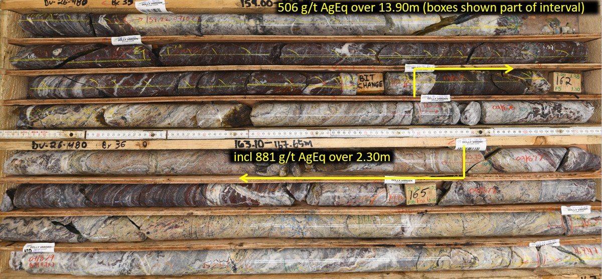
Figure 4. Drill core from DV26-480 showing layer sequences including red jasper layers and silica/barite low temperature layers and breccias with native silver, argentite, silver sulphosalts associated with galena and sphalerite mineralization. NQ core size.
To view an enhanced version of this graphic, please visit:
https://images.newsfilecorp.com/files/12610/314349_1c533b84849d291c_006full.jpg
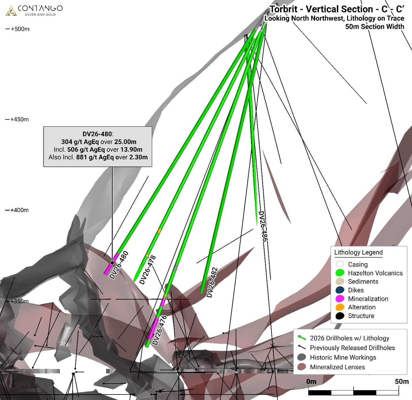
Figure 5. Cross sectional view C-C' zoom in of Torbrit deposit showing DV26-480 relative to historic underground workings and modelled mineralized lenses. 2026 drilling highlighted with lithology on trace and historic underground levels and stopes in grey.
To view an enhanced version of this graphic, please visit:
https://images.newsfilecorp.com/files/12610/314349_1c533b84849d291c_007full.jpg
Drill hole DV26-515 was drilled to confirm the extent of a number of lenses or layers along the eastern edge of the Torbrit deposit. This hole was drilled along section into the centre of the deposit. The extension of the lenses was confirmed by encountering Torbrit style mineralization within jasper and barite crystal layers with silver sulphosalts and argentite the predominant silver mineralization (Figure 6).
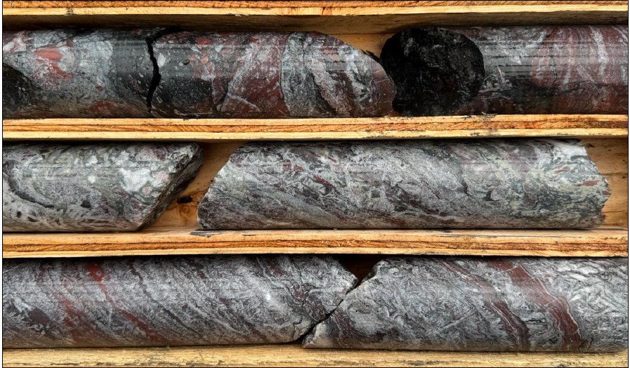
Figure 6: Drill core from DV26-515 at 105m depth. Torbrit style mineralization with mm-scale layers of sulfosalts (black) interstitial with jasper (red) and barite (white).
To view an enhanced version of this graphic, please visit:
https://images.newsfilecorp.com/files/12610/314349_1c533b84849d291c_008full.jpg
North Star and Connection Drill Holes
Drill holes at the North Star deposit were drilled from surface to intersect the mineralized horizon at a better angle with modern holes for resource confirmation . Drill hole DV26-494 tested up dip of the access adit at North Star and confirmed the thickness and continuity of mineralization (Figures 7&8). Mineralization at North star is base metal rich with increased galena and sphalerite within a barite/silica layer extending distal west from the Torbrit deposit.
Extension drilling confirmed the Torbrit-North Star connection in drill holes DV26-551, 548 and 545 (see Figure 2). Assays are pending for these mineralized zones.
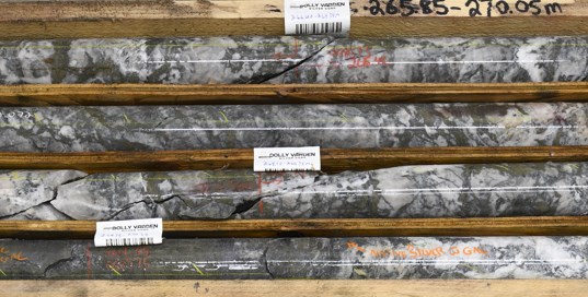
Figure 7: Drill core from DV26-494 at North Star from mineralized zone at 265.42 to 270.38m grading 807 g/t AgEq over 4.96 meter. Silver mineralization is hosted in more barite/silica layered and brecciated style.
To view an enhanced version of this graphic, please visit:
https://images.newsfilecorp.com/files/12610/314349_1c533b84849d291c_009full.jpg
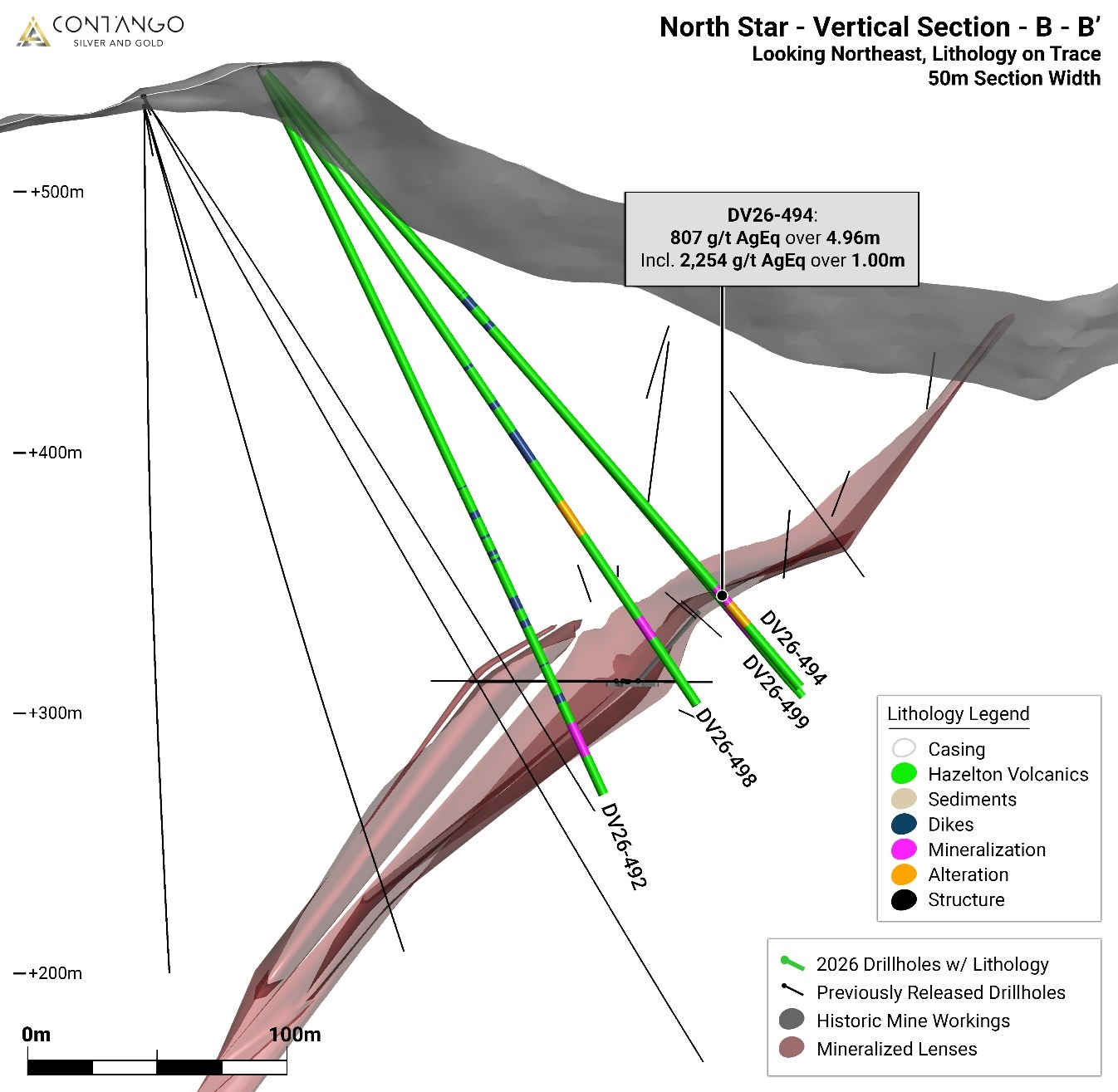
Figure 8. Cross sectional view B-B' of North Star horizon and drill hole DV26-494 drilled perpendicular to mineralization layers
To view an enhanced version of this graphic, please visit:
https://images.newsfilecorp.com/files/12610/314349_1c533b84849d291c_010full.jpg
Cautionary Note Regarding Exploration Results
The Company cautions that drill intercept lengths reported in this release are downhole core lengths. True widths are not yet known and may be materially different from reported interval lengths. Visible-gold observations are qualitative geological observations and do not necessarily correlate with higher gold grades, mineral continuity, metallurgical performance or economic significance. Gold assay results derived from laboratory analysis are the only quantitative measure of gold content.
The Kitsault Valley is an exploration-stage property. No mineral reserves have been declared for the Kitsault Valley Project, and the work described in this release is exploratory in nature. The exploration results reported in this release do not demonstrate economic viability.
Quality Assurance and Quality Control
All drill core was logged and photographed at the Alice Arm Exploration Camp. Core was sawn lengthwise using a diamond saw. One half was placed in sealed bags for analysis and the remaining half was retained. Samples were transported under documented chain-of-custody procedures to ALS Canada Ltd. in North Vancouver, British Columbia. ALS is independent of Contango and is accredited to ISO/IEC 17025 for the applicable analytical methods. Quality assurance and quality control procedures include the regular insertion of certified reference materials, blanks and duplicate samples into the analytical stream. Third party laboratory checks on 5% of the samples are carried out at the end of the field program.
Analytical testing was performed by ALS Canada Ltd. in North Vancouver, British Columbia. The entire sample is crushed to 70% minus 2mm (10 mesh), of which a 500 gram split is pulverized to minus 200 mesh. Multi-element analyses were determined by Inductively Coupled Plasma Mass Spectrometry (ICP-MS) for 48 elements following a 4-acid digestion process. High grade silver testing was determined by Fire Assay with either an atomic absorption, or a gravimetric finish, depending on grade range. Au is also determined by fire assay on a 30g split with either atomic absorption, or gravimetric finish, depending on grade range. Metallic screen on a 1.0kg sample may be completed on high-grade gold samples.
Qualified Person
The scientific and technical information contained in this news release has been reviewed and approved by Dave Larimer, CPG, Vice President, Exploration of Contango. Mr. Larimer is a "qualified person" as defined in Subpart 1300 of Regulation S-K and National Instrument 43-101. Mr. Larimer is an employee of, and is not independent of, the Company. Mr. Larimer has verified the data disclosed in this news release as described under "Quality Assurance and Quality Control."
ABOUT CONTANGO
Contango is a NYSE American and TSX listed company that engages in the exploration for and development and production of gold and associated minerals in Alaska and in the Golden Triangle in British Columbia. Contango holds a 30% interest in the Peak Gold JV, which leases approximately 675,000 acres of land for exploration and development on the Manh Choh project, with the remaining 70% owned by KG Mining (Alaska), Inc., an indirect subsidiary of Kinross Gold Corporation, operator of the Peak Gold JV. The Company and its subsidiaries also have (i) a lease on the Johnson Tract project, which consists of mineral rights to approximately 21,000 acres located near tidewater, 125 miles southwest of Anchorage, Alaska, from the underlying owner, CIRI, (ii) a lease on the Lucky Shot project, which consists of mineral rights to approximately 8,600 acres of State of Alaska and patented mining claims located in the Willow Mining District about 75 miles north of Anchorage, Alaska, from the underlying owner, Alaska Hardrock Inc., (iii) mineral rights to approximately 145,000 acres of State of Alaska mining claims, and (iv) mineral rights to approximately 11,700 acres of State of Alaska mining claims and upland mining leases, all of which give Contango the exclusive right to explore and develop minerals on these lands, and (v) mineral tenures of approximately 247,000 acres (100,000 ha) located in and around the Kitsault Valley in the Golden Triangle of northwest British Columbia.
Additional information can be found on our web page at www.contangoore.com.
FORWARD-LOOKING STATEMENTS
This press release contains forward-looking information and forward-looking statements within the meaning of applicable securities ("Forward-looking Statements"). These include statements regarding Contango's plans and expectations for its properties and operations, the content within future annual filings, operations in respect of Contango mineral properties and any benefits of investment in Contango. The Forward-looking Statements regarding Contango are intended to be covered by the safe harbor for "forward-looking statements" provided by the Private Securities Litigation Reform Act of 1995, based on Contango's current expectations and includes statements regarding future results of operations, quality and nature of the asset base, the assumptions upon which estimates are based and other expectations, beliefs, plans, objectives, assumptions, strategies or statements about future events or performance (often, but not always, using words such as "expects", "projects", "anticipates", "plans", "estimates", "intends", "believes", "ensures", "forecasts", "predicts", "proposes", "contemplates", "aims", "seeks", "continues", "potential", "positioned", "strategy", "outlook", "future", "going forward", "designed to", and similar expressions or other words of similar meaning, and the negatives thereof, or stating that certain actions, events or results "may", "might", "will", "should", "would", or "could" be taken, or that they are "possible", "probable", or "likely" to occur or be achieved). However, the absence of these words does not mean that the statements are not forward-looking. Forward-looking Statements are based on current expectations, estimates and projections that involve a number of risks and uncertainties, which could cause actual results to differ materially from those reflected in the statements. These risks include, but are not limited to: the risks of the exploration and the mining industry (for example, operational risks in exploring for and developing mineral reserves); risks and uncertainties involving geology; the speculative nature of the mining industry; the uncertainty of estimates and projections relating to future production, costs and expenses; the volatility of natural resources prices, including prices of gold and associated minerals; the existence and extent of commercially exploitable minerals in properties acquired by Contango or the Peak Gold JV; ability to realize the anticipated benefits of the Peak Gold JV; potential delays or changes in plans with respect to exploration or development projects or capital expenditures; the interpretation of exploration results and the estimation of mineral resources; the loss of key employees or consultants; health, safety and environmental risks; risks related to weather and other natural disasters; uncertainties as to the availability and cost of financing; Contango's inability to retain or maintain its relative ownership interest in the Peak Gold JV; inability to realize expected value from acquisitions; inability of our management team to execute its plans to meet its goals; the extent of disruptions caused by an outbreak of disease, such as the COVID-19 pandemic; and the possibility that government policies may change, political developments may occur or governmental approvals may be delayed or withheld, including as a result of presidential and congressional elections in the U.S. or the inability to obtain mining permits. Additional information on these and other factors which could affect Contango's operations or financial results are included in Contango's other reports on file with the U.S. Securities and Exchange Commission. Investors are cautioned that any Forward-looking Statements are not guarantees of future performance and actual results or developments may differ materially from the projections in the Forward-looking Statements. Forward-looking Statements are based on the estimates and opinions of management at the time the statements are made. Contango does not assume any obligation to update Forward-looking Statements should circumstances or management's estimates or opinions change.
CONTACTS:
Contango Silver & Gold Inc.
Rick Van Nieuwenhuyse
(907) 388-7770
www.contangoore.com
To view the source version of this press release, please visit https://www.newsfilecorp.com/release/314349