WestGold Defines ~2 km Priority Target at Amie Gold-Silver Project and Expands Idaho Land Package
 | |||||||||
 |  | ||||||||
Vancouver, British Columbia – TheNewswire - September 10, 2026 – WestGold Metals Corp. ("WestGold" or the "Company") (CSE: WGM; OTCQB: WGMTF; FSE: V0U) is pleased to announce that, further to its August 18, 2026 news release, it has completed its review of the historical technical database for its Idaho Portfolio, including a 2025 induced polarization ("IP") survey at Amie and a 2024 independent structural mapping study, both commissioned by IDEX Metals Corp. ("IDEX"). The Company also announces an expansion of its claim package and the commencement of a surface exploration program.
Highlights
-
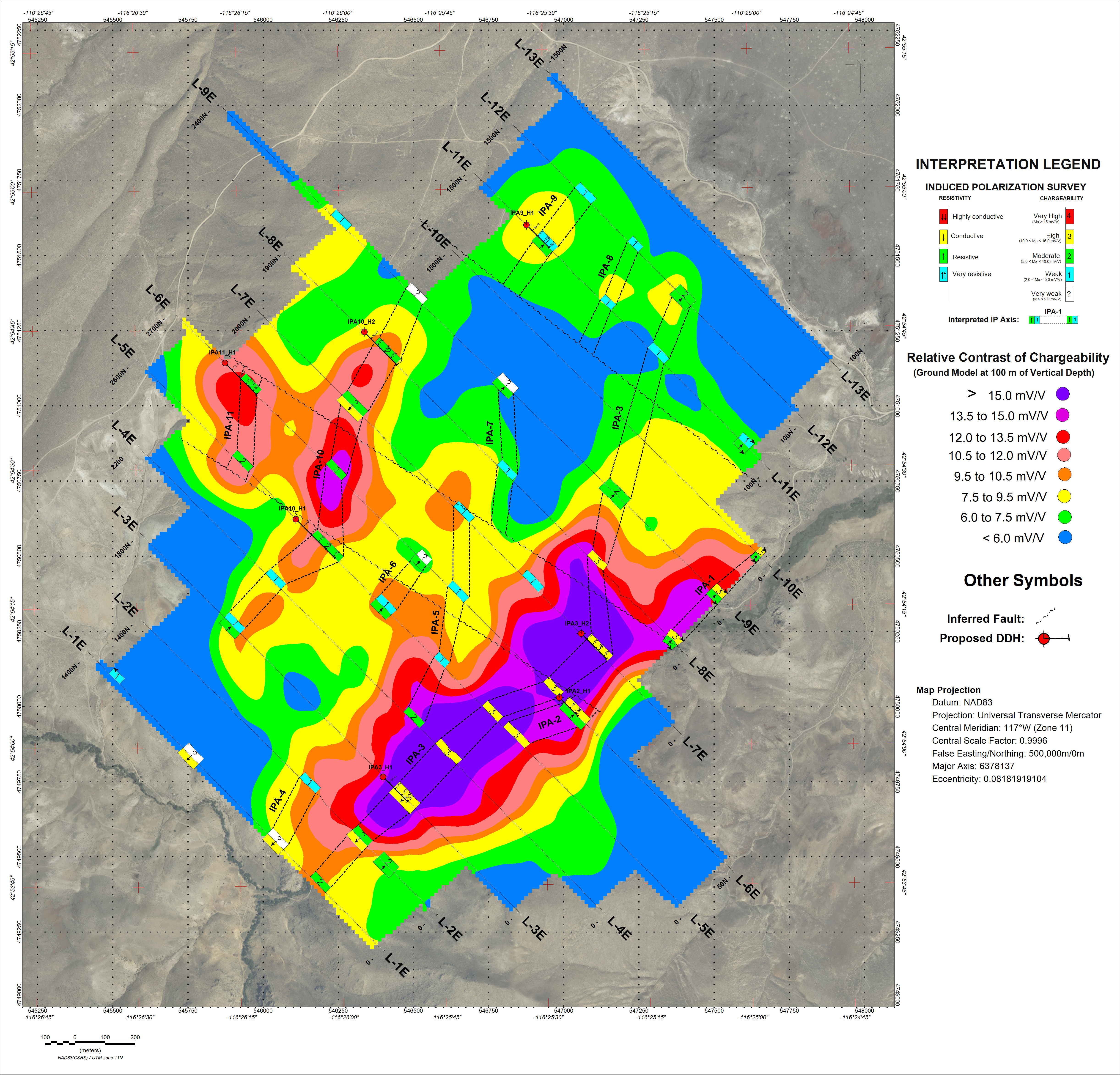
A coherent chargeability anomaly approximately 1,950 metres in length. Three-dimensional modelling of the 2025 IP survey defines a principal chargeability body approximately 1,950 metres long, together with a second body approximately 730 metres long to the northwest, coincident in part with mineralised structures mapped at surface and open along strike. Eleven IP targets were delineated across the property.
-
Independent structural study concluded Amie is "a project of merit" and "drill ready”. The independent study identified a possible multi-phase system at Amie. These multi-phase systems are known to host significant deposits in the area including the Delamar Project owned by Integra Resources, which hosts 4.6 Moz of gold (1.26 Moz Reserves, 2.95 Measured and Indicated, 0.4 Moz Inferred) and 211.4 Moz Ag (52.3 Moz Reserves, 144.2 Moz Measured and Indicated, 14.9 Moz Inferred).
-
Geophysics and structure combined into a single drill plan. WestGold has integrated the geophysical and structural datasets with historical soil geochemistry, rock sampling and mine workings, and has revised proposed drill collar positions and orientations accordingly.
-
High-grade gold and silver at surface. Historical selective sampling at Amie has returned values up to 106.8 g/t gold and, in a separate sample, up to 1,875 g/t silver.*
-
Amie has an existing Mining Notice. Drilling at the Amie Project is authorised under a Mining Notice previously approved by the U.S. Bureau of Land Management (BLM”). WestGold is completing the transfer of the Notice into its name and renewing it for a further two-year term, meaning the Company is not starting the drill permitting process from scratch.
-
Idaho land package expanded. The Company has staked an additional 37 unpatented lode claims covering approximately 308.8 hectares at the Amie project, increasing the Idaho Portfolio to 124 claims covering approximately 984.5 hectares.
-
Current field program to support drill design. A 566-sample soil geochemical program, together with geological mapping and rock sampling, is underway at Amie and Silver Rock. This represents the final field component required to finalise the maiden drill design at Amie.
Completion of Technical Review
WestGold's technical team, led by Vice President Exploration Antoine Soucy-Fradette, began compiling and reinterpreting the technical database for the Idaho Portfolio during its due diligence on the properties, and has continued that work through completion of the option agreement and into the design of the current field program.
The database comprises 978 soil samples collected within the Amie claim boundary in 2023 on a grid of 100 metre-spaced lines with 50 metre sample intervals; 137 rock chip, outcrop, pit and dump grab samples collected across the property between 2021 and 2024; short-wave infrared spectral analysis of 58 rock samples; historical mine plans and sampling records held by the Idaho Geological Survey; a 2024 independent technical report prepared under National Instrument 43-101 – Standards of Disclosure for Mineral Projects (“NI 43-101”); and the two studies described below.
2025 Induced Polarization Survey
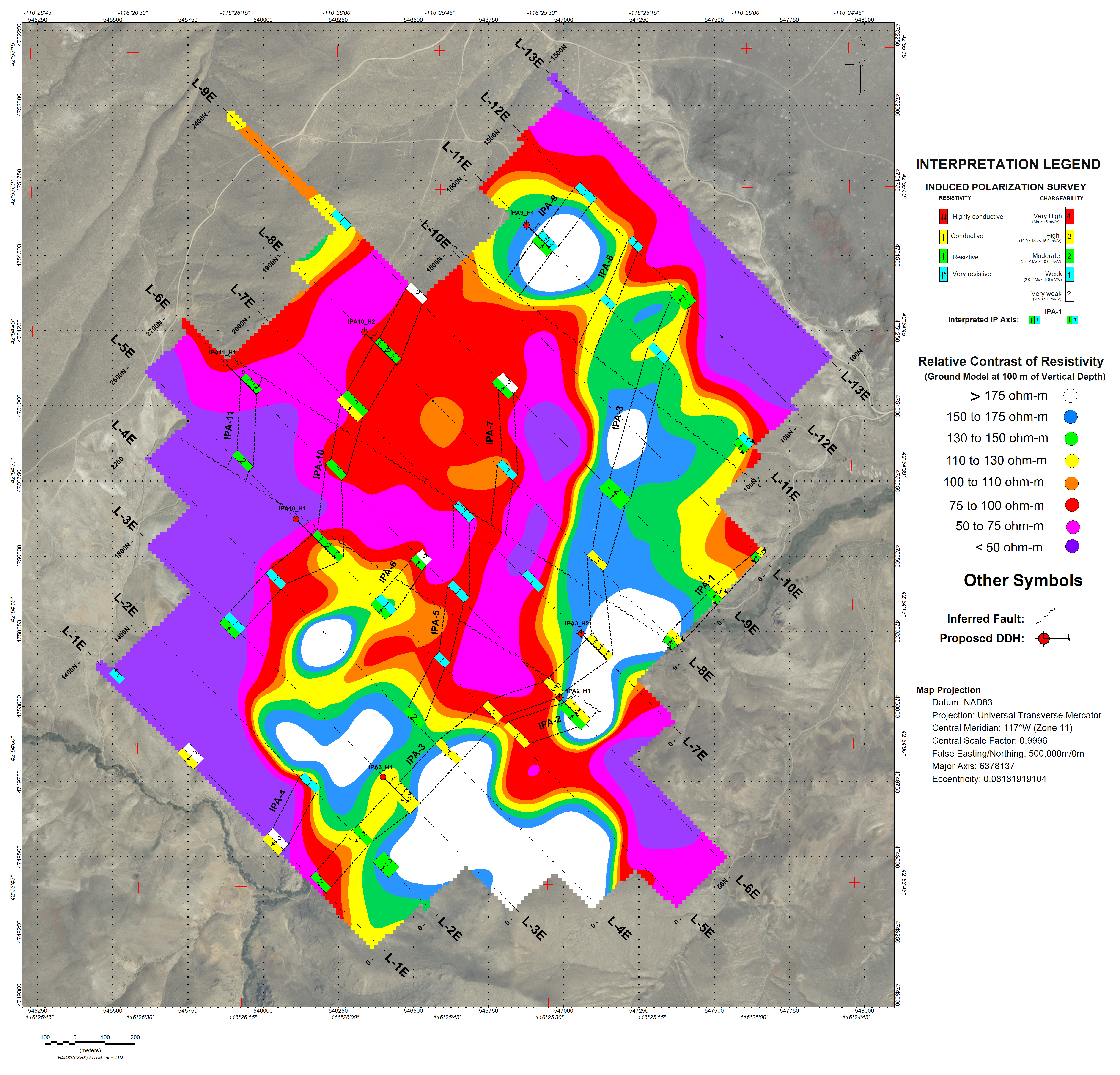
An IP survey was completed at the Amie Project by TMC Geophysics on behalf of IDEX between November 20 and December 10, 2025. The survey comprised 24.05 line-kilometres of data acquired along 13 northwest–southeast oriented lines spaced 200 metres apart, using a pole-dipole electrode array with 50 metre dipole spacing. Three-dimensional inversion models of resistivity and chargeability were generated to a vertical depth of approximately 275 metres.
The survey delineated eleven polarizable target areas, designated IPA-1 to IPA-11. Measured chargeability values across the grid ranged from -0.9 to 22.3 mV/V, with an average of 7.5 mV/V. The anomalies are interpreted by the survey author as reflecting relatively thick bands of altered rock enriched in disseminated sulphides, rather than massive sulphide accumulations, and are described as favourable targets to host gold and/or silver mineralisation.
The two highest-priority axes identified are:
-
IPA-3 – a broad, locally sub-outcropping target striking approximately north-northeast, open to the southwest, and locally coincident with the eastern mineralised corridor mapped at surface covering the Overall mine and adits.
-
IPA-10 – a broad target striking approximately north-northeast, open to the northeast and covering the location of the Amie Mine.
The survey report proposes seven diamond drill holes totalling approximately 1,535 metres, at depths of between 175 and 260 metres, to test five prioritised IP axes.
Click Image To View Full Size
Figure 1: Apparent Resistivity at 100m Vertical Depth Showing IP Axes
Click Image To View Full Size
Figure 2: Apparent Chargeability at 100m Vertical Depth Showing IP Axes
Click Image To View Full Size
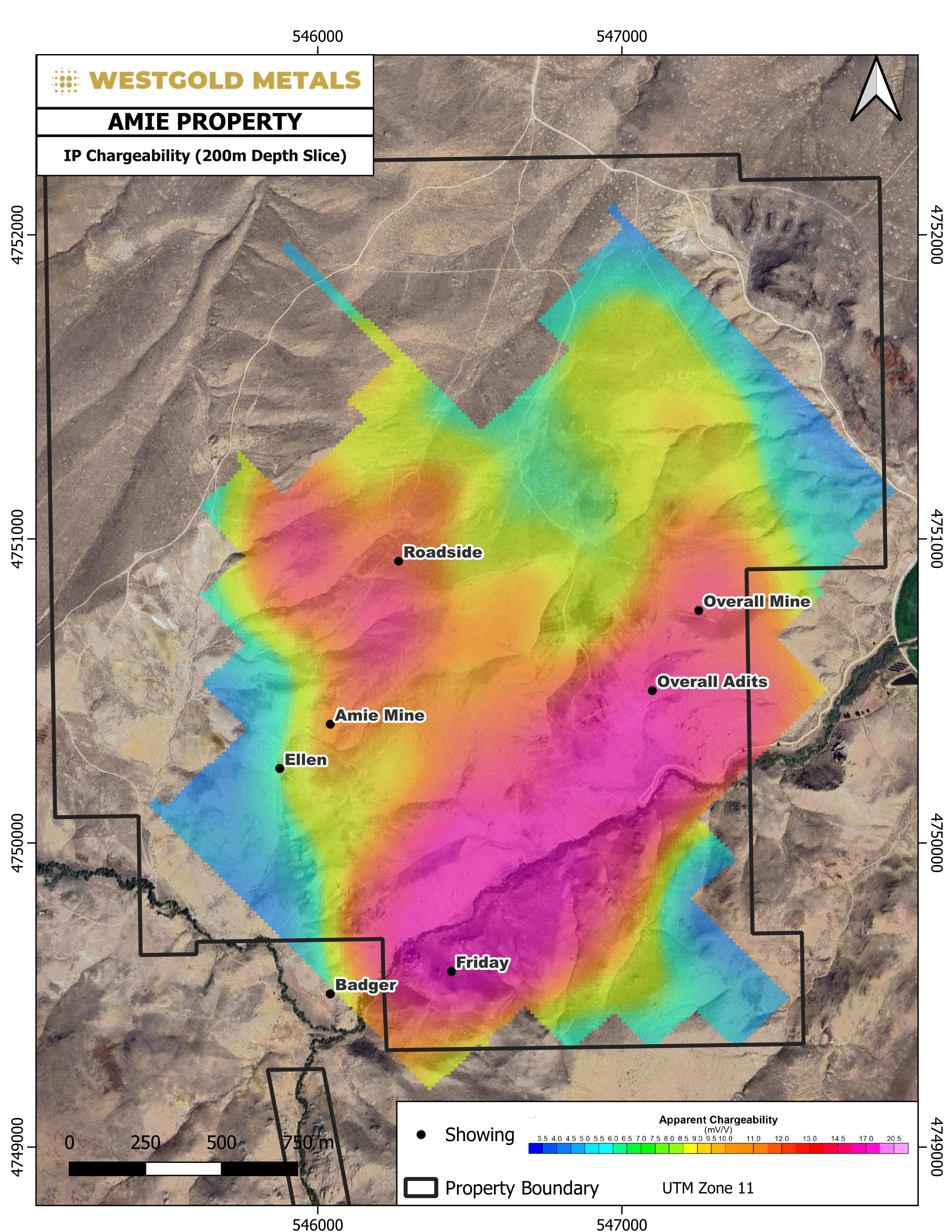
Figure 3: Apparent Chargeability at 200m Depth Slice
2024 Structural Mapping Study
A program of detailed geological and structural mapping was completed at Amie in 2024 by Specialised Geological Mapping Ltd (“SGM”) of the United Kingdom, on behalf of IDEX. The work was carried out by Dr. Luca Smeraglia and Dr. Warren Pratt (PhD, CGeol) and reported in September 2024. Key conclusions include:
-
Mineralisation is hosted within a Cretaceous granitoid intruded by pegmatite and aplite dikes and intercalated with bands of biotite schist, unconformably overlain by post-mineral conglomerate, dacitic crystal tuff and basalt.
-
Mineralisation comprises hydrothermal breccias up to 1.5 metres wide and crustiform quartz–sulphide–chalcedony veins up to 0.1 metres wide, developed along faults striking north, northeast and east–west.
-
The overall setting is interpreted as a low-sulphidation epithermal system. The presence of rare dickite and vuggy silica clasts in dump material at the Overall Mine is interpreted to suggest a possible transition toward a high-sulphidation, advanced argillic environment.
-
Rock geochemistry shows gold correlating strongly with lead, zinc and arsenic, but correlating poorly with silver and antimony, which is interpreted to indicate at least two separate mineralising events.
-
Structural control is interpreted to be exercised by through-going north-striking faults, with east- and east-northeast-striking structures interpreted as subsidiary extensional structures. Higher-grade zones are expected to occur as discrete oreshoots at dilational jogs, fault intersections and hanging-wall splits — a geometry the authors consider analogous to the La Libertad Mine in Nicaragua.
-
Post-mineral cover to the north and west of the Amie Mine is interpreted to conceal potential extensions of the mineralised structures.
-
Unusual coarse muscovite (“greisen-type”) veinlets observed in the granitoid are interpreted by the authors as forming at temperatures too high for an epithermal system and as possibly associated with a concealed porphyry system at depth. This concept remains untested.
The SGM report concluded that “the Amie prospect is a project of merit and the property is drill ready” and recommended that drill orientations be planned specifically against the mapped fault and hydrothermal breccia orientations at each prospect.
Integration and Revised Drill Targeting
The Company has rendered the three-dimensional chargeability and resistivity inversion models from the 2025 IP survey against the 2024 surface geological map, mapped fault and hydrothermal breccia traces, historical workings and proposed drill collar positions. At a chargeability threshold of 12 mV/V, the principal anomaly forms a coherent body approximately 1,950 metres in length, with a second body approximately 730 metres in length to the northwest. This work formed the basis for the Company's review of proposed collar positions and orientations.
The IP survey and the structural mapping study were commissioned separately and completed independently of one another, and each recommends a different approach to drill orientation. The drill holes proposed in the IP report are oriented perpendicular to the geophysical survey lines in order to test the chargeability axes across strike, whereas the structural study recommends orientations determined by the measured fault and breccia geometry at each individual prospect.
WestGold’s review has reconciled the two datasets and revised the proposed drill layout so that individual holes are designed to test both the chargeability anomalies and the interpreted controlling structures. In the Company’s interpretation, the chargeability axes map the extent of altered, sulphide-bearing rock at depth, while the structural model predicts where within those corridors higher-grade material is most likely to be localised. Final collar positions, azimuths and depths will be confirmed following completion of the current surface program.
The Company further notes that the approximate 275 metre depth of investigation achieved by the 2025 IP survey is not sufficient to test the concealed porphyry concept identified in the structural study. That target remains untested and would require geophysical methods capable of imaging to greater depth.
Historical Rock Sample Results
The Amie rock sample database comprises 137 samples collected between 2021 and 2024. Selected results are set out below. These samples were selected in the field on the basis of visible mineralisation and are not representative of average grade, true width, or the tenor of mineralisation across any volume of rock. The complete dataset is available on the Company’s website at https://westgoldmetals.com/table-of-assay-results/.
|
Sample ID |
Year |
Occurrence |
Au (g/t) |
Ag (g/t) |
|
CP-AMY-08 |
2022 |
Subcrop |
106.8 |
258 |
|
CP-AMY-07 |
2022 |
Subcrop |
100.1 |
134 |
|
18093 |
2023 |
Dump |
16.1 |
109 |
|
CP-AMY-09 |
2022 |
Subcrop |
12.1 |
32.0 |
|
CP-AMY-04 |
2022 |
Subcrop |
11.1 |
30.4 |
|
SLV-61 |
2021 |
Dump grab |
9.75 |
62.7 |
|
18056 |
2023 |
Dump grab |
4.22 |
501 |
|
18009 |
2023 |
Pit |
4.04 |
1,875 |
|
SLV-65 |
2021 |
Dump grab |
3.61 |
508 |
|
18091 |
2023 |
Dump grab |
1.55 |
147 |
*Selected subcrop, pit and dump grab samples, Amie Project, 2021–2023 programs. Grab samples are selective by nature and thus may not be representative of the mineralisation in the target area.
Historical mining and prospecting at Amie is understood to have exploited near-surface, oxidised material from narrow quartz veins in sheared granite. The vertical extent of unoxidised mineralisation beneath the historical workings has never been tested by drilling. The IP survey provides the first geophysical indication that sulphide-bearing material may persist below the oxidised zone, and defining the extent and tenor of that material is the primary objective of the Company’s proposed maiden drill program.
Expansion of Idaho Claim Package
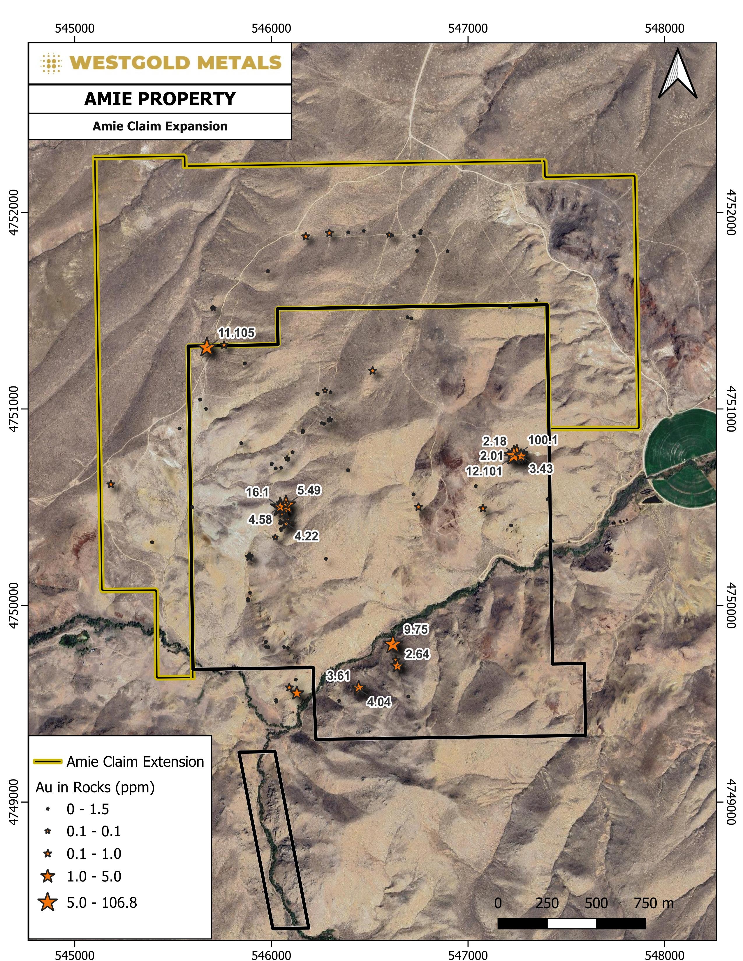
The Company has staked an additional 37 unpatented lode mining claims covering approximately 308.8 hectares on lands administered by the BLM. Claim notices were posted on September 2, 2026, and the claims will be recorded with the BLM and Owyhee County in accordance with applicable requirements.
At Amie, the claim package has increased from 53 claims covering approximately 392 hectares to 90 claims covering approximately 700.77 hectares. The expanded package covers the interpreted northerly extensions of the mineralised structures beneath post-mineral cover, including ground surrounding a historical grab sample which returned 11.1 g/t gold at the former claim boundary, together with the along-strike extensions of IP axes IPA-3 and IPA-10, both of which remain open beyond the previous claim boundary.
Following the expansion, the Idaho Portfolio comprises 124 unpatented lode claims covering approximately 984.49 hectares, compared with a corrected pre-expansion total of 87 claims covering approximately 675.72 hectares. The Company’s August 18, 2026 news release incorrectly stated that the Portfolio comprised 79 claims covering approximately 660.5 hectares.
The Company also assessed an expansion of the claim package at the Demming Project. Intervening privately held ground prevented the assembly of a contiguous package on terms the Company considered appropriate, and no additional claims have been staked at Demming at this time. The Company’s existing claim position at Demming is unaffected.
Click Image To View Full Size
Figure 4: Amie Claim Expansion
Surface Exploration Program
Palliser Exploration Ltd. (“Palliser”), an independent geological consultancy, has commenced a surface exploration program at the Amie and Silver Rock projects under the direction of WestGold’s Vice President Exploration. The program comprises:
-
Amie: collection of 97 soil samples at 50 metre intervals on 100 metre-spaced lines, extending the existing 2023 soil grid north of the Overall Mine; together with geological mapping and rock sampling of the hydrothermal breccia zone east of the Overall Mine and south of the Roadside Mine, the historical trenches north of the Overall Mine, and the workings between the Overall Mine and the Overall adits.
-
Silver Rock: collection of 469 soil samples on a 50 metre by 100 metre grid covering the claim package, together with the first systematic geological map of the property, focusing on lithology, alteration, mineralisation and structural controls.
The objectives of the program are to extend geochemical coverage over ground not previously sampled, to test the interpreted northerly continuation of the Amie mineralised structures beneath cover, to establish a first-pass geological framework at Silver Rock, and to support finalisation of drill collar positions at Amie. Samples will be submitted to MSA Labs in Elko, Nevada for preparation and shipped to MSA Langley for analysis. Results will be released when received and interpreted.
Following its announcement of August 18, 2026, the Company has determined that evaluation of the Demming Project, including verification of the historical workings and assessment of the mineralised material stockpiled on site, requires specialist work that will be undertaken as a separate program. No field work is being conducted at Demming as part of the current program.
Permitting and Regulatory
Exploration activity at Amie is conducted under a Mining Notice previously approved by the BLM, which authorises exploration involving less than five acres of surface disturbance. The Company is completing the transfer of the Notice into its name, which requires the posting of a replacement reclamation bond, and is preparing an application to renew the Notice for a further two-year term together with an updated bond calculation.
Next Steps
-
Completion of the surface exploration program at Amie and Silver Rock and receipt of analytical results.
-
Finalisation of drill collar positions, azimuths and depths for a maiden drill program at Amie, incorporating the results of the current program.
-
Extension of the current 3D interpretation into a full geological model, incorporating modelled fault and hydrothermal breccia surfaces and the results of the current surface exploration program.
-
Completion of permitting for the proposed drill program.
-
Commencement of a maiden drill program at Amie, subject to financing, completion of the Mining Notice renewal and finalisation of collar positions.
Management Commentary
James Hocking, Chief Executive Officer of WestGold, commented:
“When we closed the Idaho option in July we said we would report back once we had worked through the technical database, and our team has been on that work since due diligence. The database IDEX built includes an IP survey and an independent structural study concluding that Amie is drill ready. Our work has been to integrate the two, revise the proposed drill layout on the strength of it and expand the claim position around the priority targets.
The opportunity to acquire Amie arose as IDEX focused its attention on advancing its Freeze porphyry discovery. Amie is located in a well-established mineral district and, importantly, has never been drill tested. The work completed by IDEX has given us a substantial technical foundation from which to advance the project, rather than starting from scratch.
The field program underway is the final piece of work required to finalise our maiden drill design. Our objective is to complete that work, finish the transfer and renewal of the existing BLM Mining Notice, and move Amie toward drilling.”
Antoine Soucy-Fradette, Vice President Exploration of WestGold, commented:
“The value in this dataset is in the combination. The IP survey shows us where potential sulphide-bearing altered rock extends below cover and at depth; the structural mapping refines the location of those mineralised corridors. Joining both datasets has allowed us to position holes that test specific structures in their most prospective location below cover. The soil and mapping program now underway is designed to close the remaining gaps, particularly beneath the shallow cover north of the Overall Mine, and to give us a first proper look at Silver Rock, which has never seen modern systematic exploration.”
There are no current mineral resources or mineral reserves defined on any of the Amie, Silver Rock or Demming projects.
Qualified Person
The scientific and technical information contained in this news release has been reviewed and approved by Darren Lefort, P.Geo., a Qualified Person as defined in NI 43-101. Mr. Lefort is a consultant to the Company and is not independent of the Company for purposes of NI 43-101. Mr. Lefort has reviewed the available technical reports, assay records and supporting information underlying the historical technical disclosure. Mr. Lefort considers the available information sufficiently reliable for the purposes of describing the property’s exploration history and supporting the proposed exploration program. Sources of Technical Information
Information in this news release relating to the induced polarization survey is sourced from a report titled “Report on an Induced Polarization Survey Completed on the Amie Project, Owyhee County, Idaho, USA”, Ref. 25C-768, dated December 2025, prepared by TMC Geophysics for IDEX and authored by Joël Simard, P.Geo./Geoph.
Information relating to the structural mapping study is sourced from a report titled “Structural Controls on Gold Mineralisation at Amie, Idaho, USA”, dated September 1, 2024, prepared by Specialised Geological Mapping Ltd for IDEX and authored by Dr. Luca Smeraglia and Dr. Warren Pratt.
Information relating to soil geochemistry, rock sampling, spectral mineralogy and property geology is sourced from a technical report titled “Technical Report for the Amie Property, Owyhee County, Idaho, USA”, with an effective date of November 29, 2024, prepared by Cameron Resource Consulting, LLC and authored by Donald E. Cameron, P.G.
Historical information relating to the Demming and Silver Rock properties is sourced from a government report titled “Site Inspection Report for Abandoned and Inactive Mines in Southern Idaho: Volume III: Miscellaneous Properties, Owyhee County, Idaho”, Idaho Geological Survey Staff Report 10-3, prepared by D. H. Bennett, J. Kauffman and V. E. Mitchell in 2010 for the Bureau of Land Management.
Cautionary Note Regarding Historical and Third-Party Technical Information
The technical studies described in this news release were commissioned by, and prepared for, IDEX and its affiliates prior to WestGold’s involvement with the properties. This information has not been independently verified by WestGold. Historical exploration results and production records referred to were generated prior to the introduction of NI 43-101, and details of the sampling methods, sample security, assaying and quality control procedures applied are in some cases unknown. The information is presented for geological context and to inform the Company’s exploration planning, and should not be relied upon as representative of mineralisation that may be found or mined on the properties.
Rock chip, outcrop, pit, dump and dump grab samples referred to in this news release are selective samples taken to characterise mineralisation identified in the field. They are not representative of any particular rock volume or of in-situ grade, and should not be interpreted as indicative of the grade or continuity of mineralisation on the properties.
About WestGold Metals Corp.
WestGold Metals Corp. is a Canadian mineral exploration company focused on the identification, acquisition, and advancement of precious metal exploration opportunities in established North American mining districts. The Company is building a portfolio of high-quality assets in politically stable, mining-friendly jurisdictions, led by an experienced management team with backgrounds in equity capital markets, commercial development, and technical exploration. WestGold’s flagship assets are the Amie, Silver Rock and Demming epithermal gold-silver projects comprising the Idaho Portfolio in Owyhee County, Idaho, USA. WestGold’s common shares are listed on the Canadian Securities Exchange under the symbol WGM, quoted on the OTCQB under the symbol WGMTF, and traded on the Frankfurt Stock Exchange under the symbol V0U. For more information, investors are encouraged to review the Company’s public filings available at www.sedarplus.ca.
ON BEHALF OF THE BOARD OF DIRECTORS
James Hocking, CEO & Director
For further information, please contact:
James Hocking
Chief Executive Officer & Director
Forward-Looking Statements
This news release contains or incorporates by reference “forward-looking statements” and “forward-looking information” as defined under applicable Canadian securities legislation. All statements, other than statements of historical fact, which address events, results, outcomes, or developments that the Company expects to occur are, or may be deemed to be, forward-looking statements. Forward-looking statements are generally, but not always, identified by the use of forward-looking terminology such as “anticipate,” “expect,” “suggest,” “plan,” “believe,” “intend,” “estimate,” “target,” “project,” “should,” “could,” “would,” “may,” “will,” “forecast” and other similar expressions.
Forward-looking statements in this news release include, without limitation, statements relating to the interpretation of geophysical, geochemical and structural data; the location, orientation, depth and timing of proposed drill holes; the Company’s intention to complete a maiden drill program at Amie; the expected timing of receipt and interpretation of analytical results; the recording of newly staked mineral claims; the Company’s permitting pathway and engagement with the Bureau of Land Management; the potential for mineralisation to extend beneath post-mineral cover; the potential of a concealed porphyry system; and the Company’s planned exploration programs at the Amie, Silver Rock and Demming projects.
Forward-looking statements or information are subject to a variety of known and unknown risks, uncertainties and other factors that could cause actual events or results to differ from those reflected in the forward-looking statements or information, including, without limitation: the risk that geophysical, geochemical and structural interpretations prove incorrect or that drilling fails to identify mineralisation; the speculative nature of mineral exploration and the early stage of the Company’s properties; the need for additional capital through financings and the risk that such funds may not be raised; the risk that mineral claims are not validly located or recorded; the risk that required permits are not obtained or are delayed; the effect of changes in commodity prices; regulatory, environmental and land access risks, including seasonal wildlife habitat restrictions; the availability of drilling equipment and qualified personnel; the risk that work programs are not completed within expected time frames; the risk that the results of ongoing work programs lead to a change in exploration priorities; and the efforts and abilities of the senior management team.
Although the Company has attempted to identify important factors that could cause actual results to differ materially, there may be other factors that cause results not to be as anticipated, estimated, described or intended. Accordingly, readers should not place undue reliance on forward-looking statements or information. The Company’s forward-looking statements and information are based on the assumptions, beliefs, expectations, and opinions of management as of the date of this news release, and other than as required by applicable securities laws, the Company does not assume any obligation to update forward-looking statements and information if circumstances or management’s assumptions, beliefs, expectations or opinions should change, or changes in any other events affecting such statements or information.
Neither the Canadian Securities Exchange nor its Market Regulator (as that term is defined in the policies of the Canadian Securities Exchange) accepts responsibility for the adequacy or accuracy of this release.
Copyright (c) 2026 TheNewswire - All rights reserved.
